Bay of Bengal
|
Claimed by / Disputed by |
Bangladesh / India / Manymar |
| Area | 284.471 km2, 25.602 km2 |
| Inhabitants |
0 |
|
Claimed / Disputed |
1971 - 2014 |


Story
A decades long dispute over maritime boundaries between Bangladesh and Myanmar in the Bay of Bengal has been finally settled by the International Court of the Law of Sea in 2012. It granted Bangladesh its share of the 200 nautical mile exclusive economic zone principle. Otherwise Bangladesh, squeezed between India and Myanmar, would have had a disproportionally small share in relation to its coastline in terms of EEZ and would cut it off the continental sea shelf. In addition the ruling also determined a “Grey Zone”, where Myanmar would own the sea waters but Bangladesh would be owing the sea bed. The ruling was accepted by both countries, which in 2008 narrowly escaped naval forces conflict in the disputed maritime area.
In parallel a U.N. Court of Arbitration ruling on a disputed area of 25.602 km2 between Bangladesh and India has been made in 2014. The ruling comes after a 2009
appeal of Bangladesh to settle the dispute. The CoA awarded 19.467 km2 to Bangladesh, the ruling having been accepted by both parties involved.
Philately
Thus far only Bangladesh has issued a stamp in 2021 with a map of its boundaries including the demarcations of the 2012 and 2014 rulings with the maritime area awarded to Bangladesh.
Bangladesh
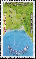
Bangladesh, 2021, Map of Bangladesh with white dashed maritime boundaries